DEEPbaseline

Co-creating a knowledge baseline on the diversity and distribution of deep-sea sponge and coral habitats of the continental shelf of mainland Portugal

Logo

DEEPbaseline

Loading project…

Co-creating a knowledge baseline on the diversity and distribution of deep-sea sponge and coral habitats of the continental shelf of mainland Portugal

Period: 01 Apr 2026 to 31 Aug 2022

Funding: 1 source(s)

AZORES DEEP-SEA RESEARCH
Time period

01 Apr 2026 to 31 Aug 2022


External website
Funding
Other

Fundação Oceano Azul; FUNDO para a Conservação dos Oceanos - 3ª Edição

Summary

Co-creating a knowledge baseline on the diversity and distribution of deep-sea sponge and coral habitats of the continental shelf of mainland Portugal

Participatory approaches (interviews and surveys) will be conducted with local fishers using bottom-contacting gear (e.g., beam-trawl, bottom longline) to gather Local Ecological Knowledge (LEK) on the spatial and historical occurrence of sponge and coral species and habitats. This information will be integrated with Conventional Scientific Knowledge (CSK) obtained through a literature review, bycatch data from multi-annual bottom-trawl surveys, and integrative taxonomic analysis of bycatch samples collected during surveys and by participating fishers. The combined knowledge will be translated into management-support tools, such as identification guides, distribution maps, and an online database, and transferred to key end-users to inform the selection of high-biodiversity areas for protection and support the implementation of regional and (inter)national conservation frameworks. Training activities will also be developed to capacitate local fishers and fisheries observers in the identification and reporting of VME-indicator species, ensuring long-term impact and sustainability.

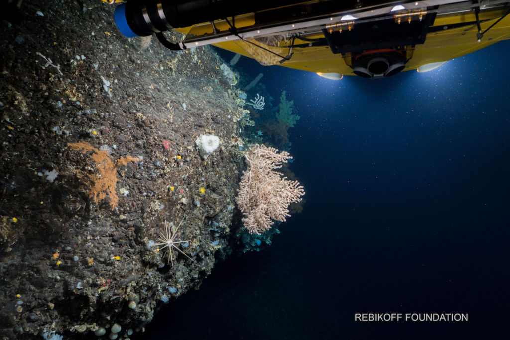
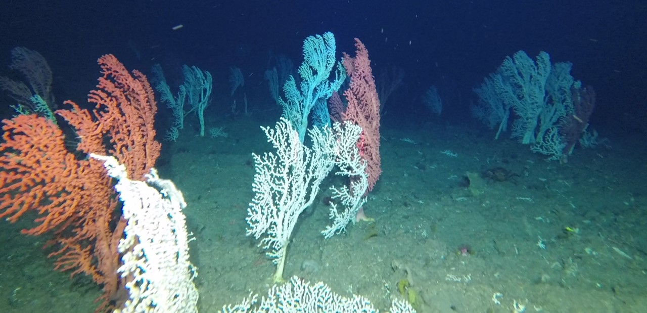
DEEPbaseline is an interdisciplinary project aimed at developing a framework for the co-creation of a knowledge baseline on the diversity and distribution of deep-sea sponge and coral vulnerable species and ecosystems of the continental shelf and upper slope of mainland Portugal. DEEPbaseline brings together scientists from four partner institutions (CIIMAR, IPMA, CESAM and Okeanos), local fishing communities and associations, fisheries managers, and the wider society to foster awareness and advance conservation actions towards their sustainability.

Show less ↑
Show more ↓

Main results

Show less ↑
Show more ↓
Cruise Report - NICO Cruise Leg 12, Hopper dives on board of R/V Pelagia
Zenodo
|
Jan, 2019
2 team members are authors
OA DOI 10.5281/zenodo.3416992
Authors 10.5281/zenodo.3416992
Dominguez-Carrió, Carlos
Gollner, Sabine Visser, Fleur
Morato, Telmo
Abstract
Objectives: to explore deep-sea areas of the Azores EEZ to better understand the distribution patterns of large VME species and commercial fishes. Specifically, IMAR/ATLAS objectives in the cruise were to (i) characterize benthic communities inhabiting unexplored seamounts, such as Cavalo and São Jorge de Fora seamounts, (ii) identify new areas that fit the FAO vulnerable marine ecosystems definition; and (iii) determine distribution patterns of deep-sea benthic biodiversity in the Azores. The results of this cruise will also contribute to identify the environmental drivers that determine the spatial distribution of deep-sea benthic biodiversity in the Azores region. It will also provide valuable information in the context of Good Environmental Status (GES), Marine Spatial Planning (MSP) and provide new insights on how to sustainably manage deep-sea ecosystems. The information gathered in this cruise was obtained by means of the Hopper tow-cam system, an HD video platform specially designed to be operated on board of the R/V Pelagia.
MapGES 2019: Summer 2019 cruise on board of N/I Arquipélago
Zenodo
|
Mar, 2020
7 team members are authors
OA Citations 1 DOI 10.5281/zenodo.3727570
Abstract
Objective: to explore seamounts of the Azorean archipelago to better understand the distribution patterns of VMEs and commercial fish species. A special interest was placed in exploring deep-sea areas along the Mid Atlantic Ridge and close to islands of the central group. The device used in this survey corresponds to the low-cost drift-cam video platform designed and developed at IMAR. Vessel: N/I Arquipélago Chief scientist: Telmo Morato Scientific team: Telmo Morato, Carlos Dominguez-Carrió, Sérgio Gomes, Gerald H. Taranto, Jordi Blasco, Manuela Ramos, Laurence Fauconnet, Cristina G. Zárate, Marina Carreiro-Silva Main achievements: Successfully tested the new design of the low-cost drift-cam system developed at IMAR Exploration of over 80 km of seabed down to 750 m depth in 8 different areas for which little or no information of its benthic communities was available Discovery of new sites that host diverse coral gardens and sponge grounds that were unknown to science New data on the distribution of VMEs in the seamounts of the Mid-Atlantic Ridge
Cruise report for 64PE488 onboard of R/V Pelagia Terceira Island 2021 - Towed camera video footage
Zenodo
|
Jun, 2021
3 team members are authors
OA DOI 10.5281/zenodo.6592634
Abstract
Objectives: To explore deep-sea areas of the Azores EEZ to better understand the distribution patterns of large VME species and commercial fishes. Specifically, the objectives of the cruise were to (i) continue the characterization of benthic communities inhabiting the slopes of Terceira and neighboring submarine ridges, (ii) identify new areas that may fit the FAO definition of what constitutes a Vulnerable Marine Ecosystem; and (iii) to contribute with additional data to address patterns and drivers of the distribution of deep-sea benthic biodiversity in the Azores region. It will also provide valuable information in the context of Good Environmental Status (GES), Marine Spatial Planning (MSP) and provide new insights on how to sustainably manage deep-sea ecosystems. Vessel: R/V Pelagia Chief scientist: Fleur Visser (NIOZ) Scientific team: Manuela Ramos (IMAR-UAç) Cruise summary: Six new dives were performed by the towed camera system of R/V Pelagia during the cruise. Four dives were performed on the southern Terceira island depression, covering a depth range between 1300 and 1900 m. The remaining two dives were performed in the Serreta Ridge, WNW of Terceira, between 780 and 1100 m depth. Overall, we collected 6 h of new video footage.
Nothing to show yet... Try again later.
Fishers’ Local Ecological Knowledge of vulnerable marine ecosystems indicator species on the Portuguese continental shelf and upper slope
Ecosystems and People
|
Oct, 2025
1 team member is author
OA DOI 10.1080/26395916.2025.2566067
Authors 10.1080/26395916.2025.2566067
Ana Rita Soares Ana Hilário
Marina Carreiro‐Silva
Sandra Ramos Cristina Pita Joana R. Xavier
Abstract
16 pages, 6 figures, 1 table
Spatial distributions, environmental drivers and co-existence patterns of key cold-water corals in the deep sea of the Azores (NE Atlantic)
Deep Sea Research Part I Oceanographic Research Papers
|
Mar, 2023
7 team members are authors
OA Citations 20 DOI 10.1016/j.dsr.2023.104028
A cost‐effective video system for a rapid appraisal of deep‐sea benthic habitats: The Azor drift‐cam
Methods in Ecology and Evolution
|
Apr, 2021
2 team members are authors
OA Citations 38 DOI 10.1111/2041-210x.13617
Authors 10.1111/2041-210x.13617
Abstract
Abstract Deep‐sea exploration relies on cutting‐edge technology, which generally requires expensive instruments, highly specialized technicians and ship time. The increasing need to gather large‐scale data on the distribution and conservation status of deep‐sea benthic species and habitats could benefit from the availability of low‐cost imaging tools to facilitate the access to the deep sea world‐wide. Here we describe the Azor drift‐cam, a cost‐effective video platform designed to conduct rapid appraisals of deep‐sea benthic habitats. Built with off‐the‐shelf components, the Azor drift‐cam should be regarded as an effective, affordable, simple‐to‐assemble, easy‐to‐operate, resilient, operational and reliable tool to visually explore the deep sea to 1,000 m depth. Its performance was assessed during the MapGES_2019 cruise, where 135 successful dives between 100 and 800 m depth were carried out in 22 working days, providing over 100 hr of images for almost 80 km of seabed, mostly in areas that had never been explored before. The system does not aim to become a substitute for more sophisticated underwater video and photography platforms, such as ROVs, AUVs or manned submersibles. Rather, it aims to provide the means to perform quick assessments of deep‐sea benthic habitats in a simple and affordable manner. This drift‐cam system has the potential to make deep‐sea exploration more accessible, playing an important role in the Deep‐Ocean Observing Strategy and measuring some of the Essential Ocean Variables for deep‐sea monitoring and conservation strategies.
Predicting the distribution and abundance of abandoned, lost or discarded fishing gear (ALDFG) in the deep sea of the Azores (North Atlantic)
The Science of The Total Environment
|
Aug, 2023
9 team members are authors
OA Citations 19 Rising DOI 10.1016/j.scitotenv.2023.166579
Authors 10.1016/j.scitotenv.2023.166579
Emily M. Duncan Nina Vieira
José Manuel González‐Irusta
Carlos Dominguez‐Carrió
Telmo Morato
Marina Carreiro‐Silva
Joachim Jakobsen Kirsten Jakobsen
Filipe M. Porteiro
Nina Schläpfer Laura Herrera
Manuela Ramos
Yasmina Rodríguez
João Pereira
Laurence Fauconnet
Luís Rodrigues
Hugo Parra Christopher K. Pham
Abstract
Abandoned, lost, or discarded fishing gear (ALDFG), represents a significant percentage of the global plastic pollution, currently considered one of the major sources from sea-based activities. However, there is still limited understanding of the quantities of ALDFG present on the seafloor and their impacts. In this study, data on the presence of ALDFG was obtained from a large archive of seafloor video footage (351 dives) collected by different imaging platforms in the Azores region over 15 years (2006-2020). Most ALDFG items observed in the images relate to the local bottom longline fishery operating in the region, and include longlines but also anchors, weights, cables and buoys. A generalized additive mixed model (GAMM) was used to predict the distribution and abundance of ALDFG over the seafloor within the limits of the Azores Exclusive Economic Zone (EEZ) using a suite of environmental and anthropogenic variables. We estimated an average of 113 ± 310 items km-2 (597 ± 756 per km-2 above 1000 m depth), which could imply that over 20 million ALDFG items are present on the deep seafloor of the Azores EEZ. The resulting model identified potential hotspots of ALDFG along the seabed, some of them located over sensitive benthic habitats, such as specific seamounts. In addition, the interactions between ALDFG and benthic organisms were also analysed. Numerous entanglements were observed with several species of large anthozoans and sponges. The use of predictive distribution modelling for ALDFG should be regarded as a useful tool to support ecosystem-based management, which can provide indirect information about fishing pressure and allow the identification of potential high-risk areas. Additional knowledge about the sources, amounts, fates and impacts of ALDFG will be key to address the global issue of plastic pollution and the effects of fishing on marine ecosystems.

DEEPbaseline Gallery

Follow us on social media to stay updated

Location

Institute of Marine Sciences — Okeanos, University of the Azores

Departamento de Oceanografia e Pescas — Universidade dos Açores

Rua Prof. Doutor Frederico Machado, No. 4
9901-862 Horta, Portugal

Contact

FOLLOW US
ADSR

AZORES DEEP-SEA RESEARCH © 2020-2026 — RELEASE 2.1

Developed by Valter Medeiros VALTER MEDEIROS