Loading…

DeepWalls

Exploring pristine deep-sea walls to establish baselines for Good Environmental Status in the Azores

DeepWalls

Loading project…

Exploring pristine deep-sea walls to establish baselines for Good Environmental Status in the Azores

Period: 01 May 2019 to 30 Jun 2023

Funding: 1 source(s)

AZORES DEEP-SEA RESEARCH
Time period

01 May 2019 to 30 Jun 2023


Funding
Regional ACORES-01-0145-FEDER-000124

Regional Government of the Azores, PO Açores 2020, European Regional Development Fund (ERDF / FEDER)

Budget: 179,821.00 €

Summary

Exploring pristine deep-sea walls to establish baselines for Good Environmental Status in the Azores

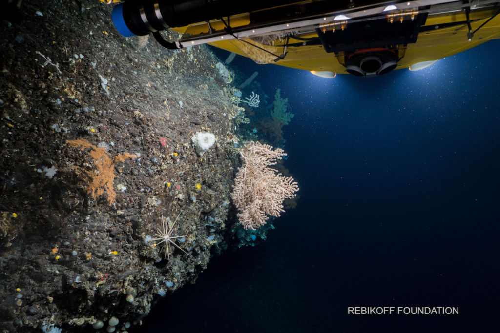
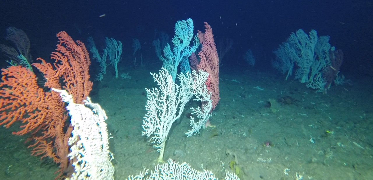
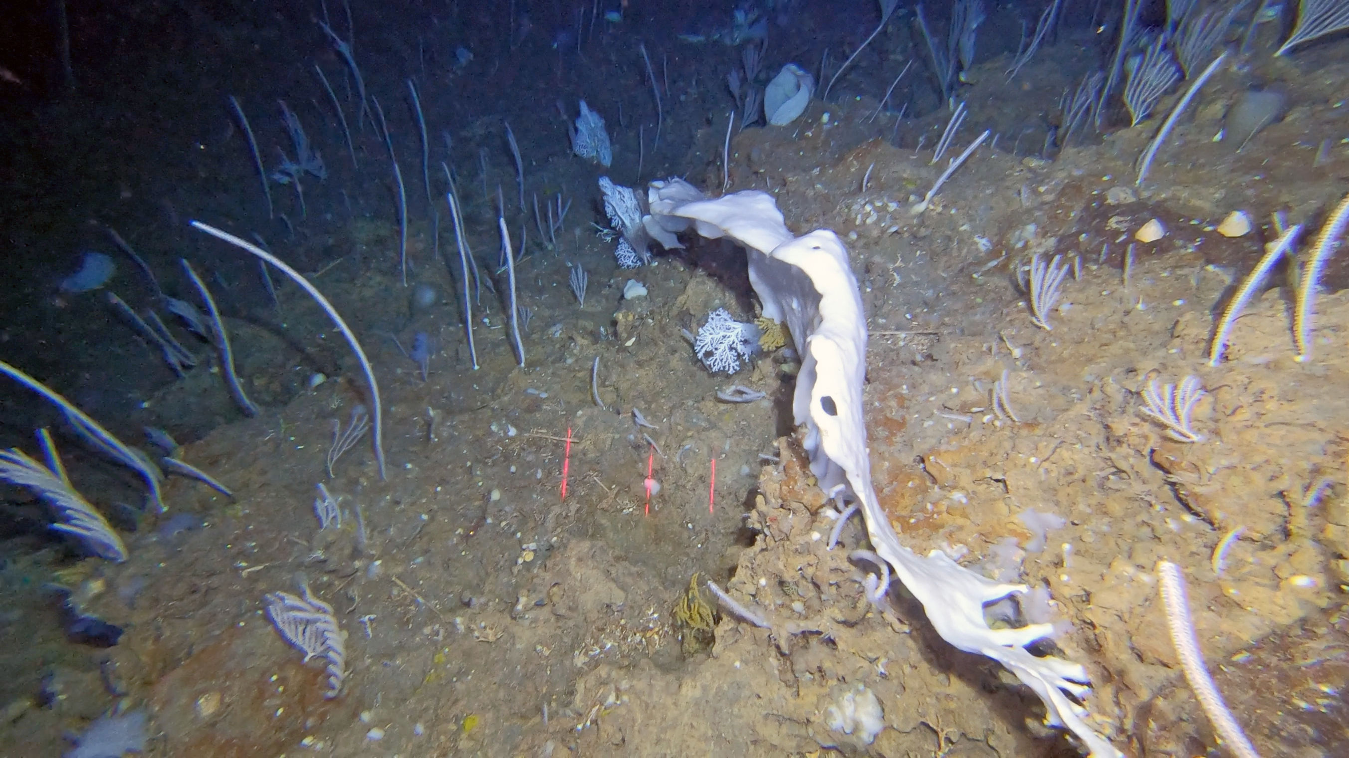
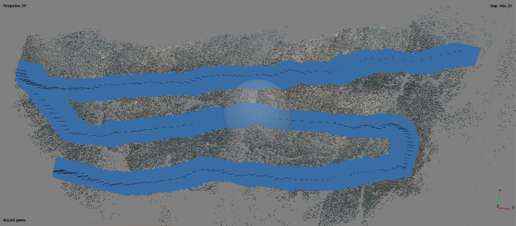
DeepWalls aims towards answering fundamental questions about the ecology of deep-sea underwater cliffs. Using a range of local knowledge and predictions from experts, and together with the Rebikoff-Niggeler Foundation, we set a quest to locate vertical walls in the deep sea surrounding the islands of the central group in the Azores. Using the submersible LULA1000 (https://www.rebikoff.org/submersible-lula-1000/), we recorded high-resolution video images of the vertical walls encountered to characterize the diversity of benthic species that inhabit them. The images obtained during several underwater dives will be used to quantify the composition and structure of the benthic communities that live on vertical walls to determine the uniqueness of the habitat they create. State-of-the-art techniques such a Structure from Motion and photogrammetry will be used to reconstruct the walls in 3D images in order to evaluate small-scale variations in the terrain and how small differences can influence species composition. The findings of this project will be used to inform baselines for Good Environmental Status as part of the demands of the Marine Strategy Framework Directive (MFSD) of the European Union. We hypothesise that deep-sea vertical walls may may have escaped the impacts of bottom fishing due to the protective posture that a vertical cliff or a wall can provide to the benthic fauna.

The Azores region harbours an array of large geomorphological features including ridges, seamounts, plateaus and abyssal plains. This complex topography hosts a variety of small-scale variations, including underwater cliffs (or vertical walls) and overhangs that create distinct habitats in the region. Characterizing their geomorphology and benthic community composition requires a feat of technology in order to navigate these complex terrains to collect data. Since most of these walls are still unexplored, many important questions remain unanswered: How much heterogeneity do vertical walls introduce into the environment at small scales? How widespread are they? Can we predict their location? Do vertical walls support unique assemblages of megabenthic species? Can these habitats be used to determine baselines for Good Environmental Status? ¡

Show less ↑
Show more ↓

Our Team's role

Azores Deep-sea Research

We lead the DeepWalls project, all the workpackages and the outreach activities.

Collaborators

David Price
Jorge Fontes
Eva Giacomello
Timm Schoening

Main results

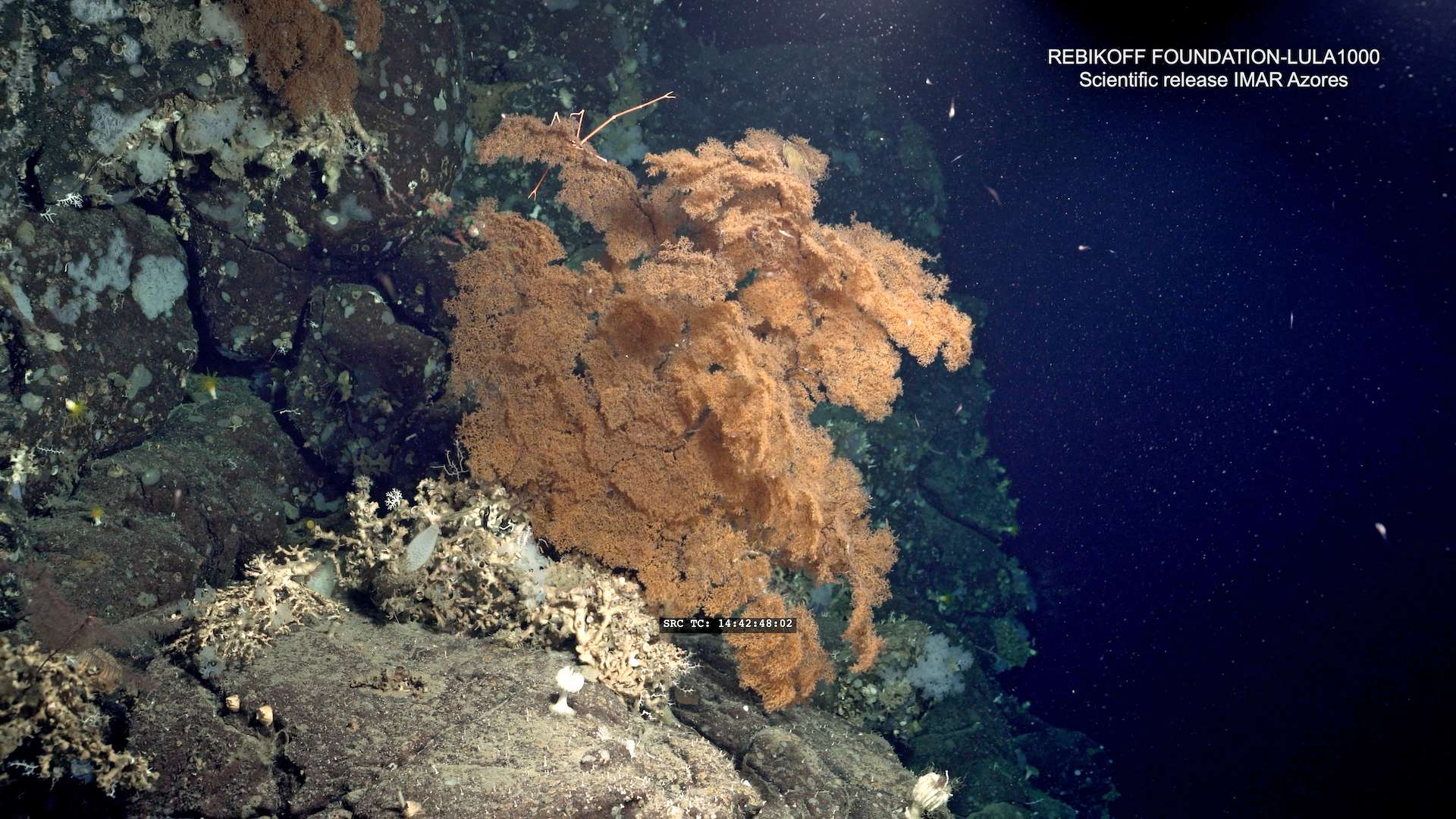
DeepWalls utilises advanced imaging technology and software processing to achieve the projects objectives. We have demonstrated that vertical walls host an abundance of life, including important reef-forming, and habitat-building cold-water coral species. Glass sponges and reef-building scleractinian corals were found on the vertical walls, which provide a 3D skeletal framework that increases the structural complexity of the habitat and likely enhances biodiversity at the local scale. Large black corals were observed, protruding over a metre from the walls, providing habitat for abundant associated fauna. We have utilised innovative and complex computer algorithms to quantify the wall in 3D images, observing a plethora of geomorphic features, which contribute to generate a rich and heterogeneous habitat.
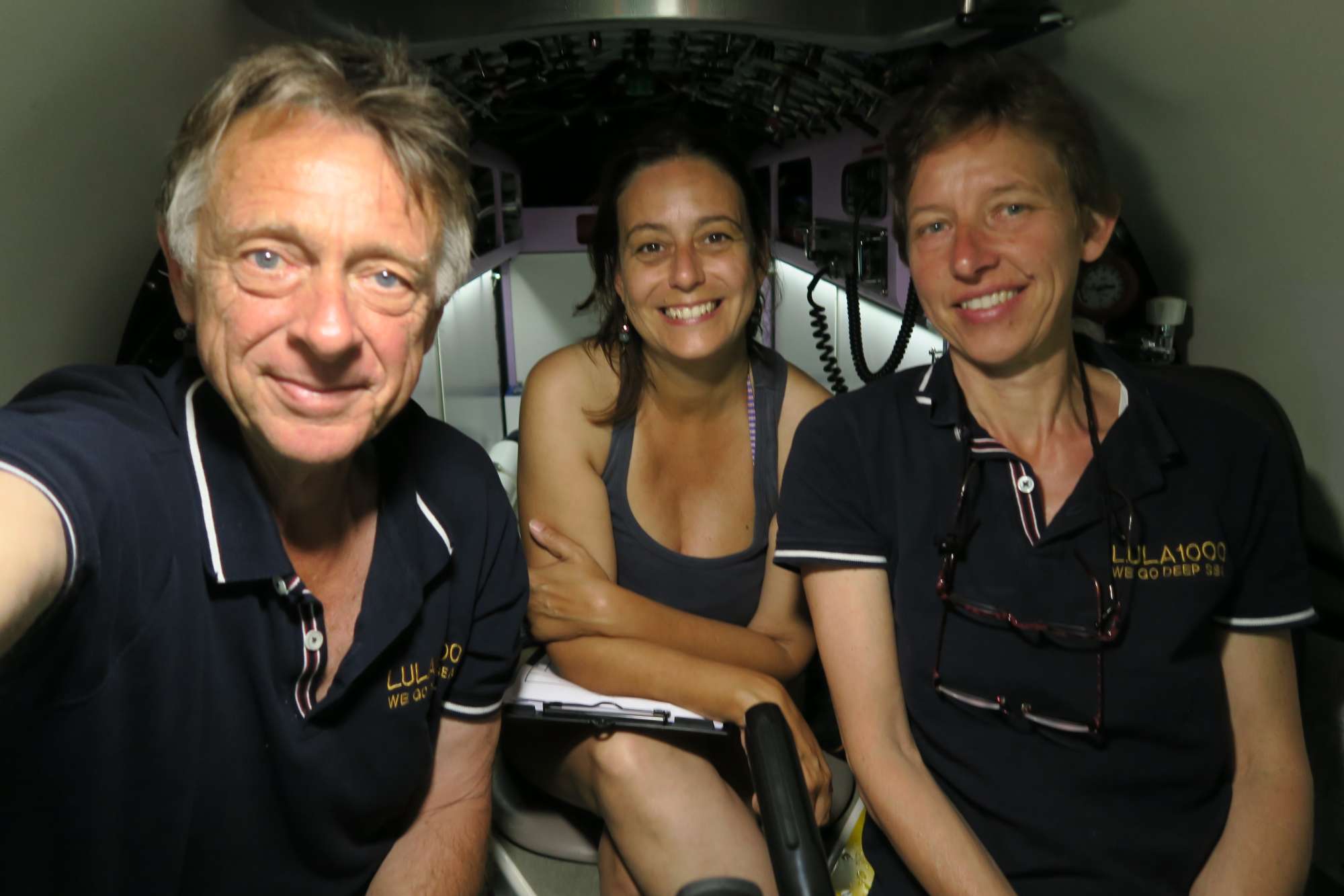
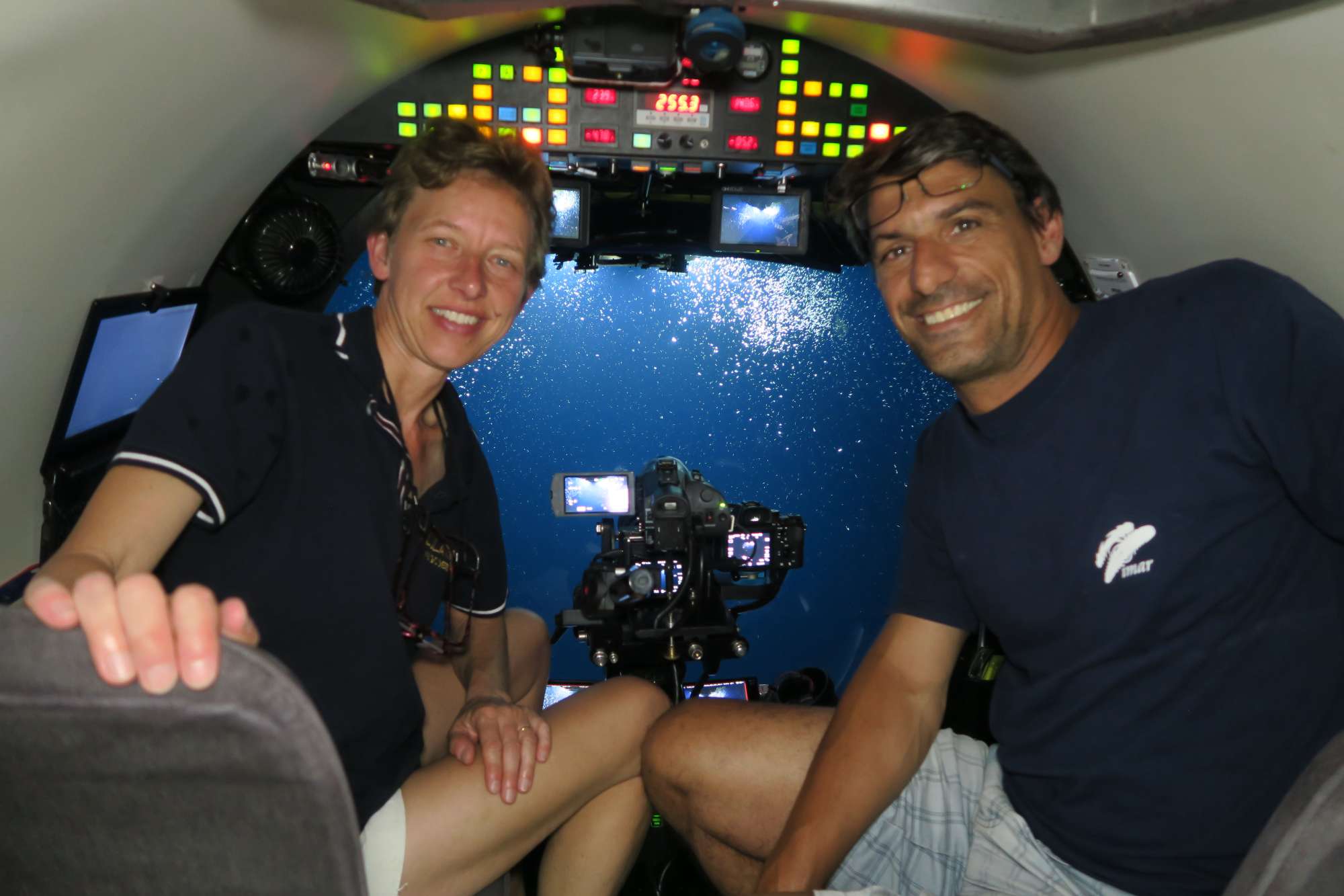
  1. Deep-sea discoveries: the Azores region hosts several deep-sea walls, ranging from small cliffs to large vertical walls.
  2. The verticals walls evaluated were mostly very steep (>70 degrees) and formed of basalt rock. Where basalt rock formed pillow lava, large heterogeneity was observed, including small overhangs, bulbous outcrops and flat surfaces where sediment would settle. This complexity created a fragmented habitat with potentially many ecological niches at scales of several metres.
  3. Deep-sea walls around the Azores are home to a variety of important habitat-forming species such as black corals, gorgonians, reef-forming cold-water corals, oysters, glass sponges and crinoids. These species contribute to the structural complexity of the walls, with potential implications for local biodiversity metrics.
  4. Underwater images revealed the capacity of black corals to harbour a high number of associated invertebrate species, including sessile (e.g. anemones, molluscs, hydrozoans) and free living (e.g. crustaceans). In some areas, black corals also harboured the eggs of deep-sea sharks, indicating the importance of such communities, not only as refuge and feeding areas for associated fauna, but also as potential nurseries for some rare or sensitive species.
  5. High abundance of black corals, sponges, cold-water scleractinian corals (which are considered VME indicators), may indicate that underwater deep-sea walls act as VMEs due to enhanced structural complexity, presence of long-lived species and their rarity.
  6. Several black corals measured over 1 m, which would suggest hundreds of years of growth, likely uninterrupted from physical impacts due to their pristine appearance. The walls may act as refugia to sensitive species, providing physical protection from example, from fishing activities.
Show less ↑
Show more ↓
Nothing to show yet... Try again later.
Towards a scientific community consensus on designating Vulnerable Marine Ecosystems from imagery
PeerJ
|
Oct, 2023
2 team members are authors
OA Citations 18 Rising DOI 10.7717/peerj.16024
Authors 10.7717/peerj.16024
Amy R. Baco Rebecca E. Ross Franziska Althaus Diva J. Amon Amelia E.h. Bridges Saskia Brix Pål Buhl‐Mortensen Ana Colaço
Marina Carreiro‐Silva
Malcolm R. Clark Cherisse Du Preez Mari-Lise Franken Matthew Gianni Genoveva Gonzalez‐Mirelis Thomas F. Hourigan Kerry L. Howell Lisa A. Levin Dhugal J. Lindsay Tina N. Molodtsova Nicole B. Morgan
Telmo Morato
Beatriz E. Mejía‐Mercado David O’sullivan Tabitha R. R. Pearman David M. Price Katleen Robert Laura E. Robson Ashley A. Rowden James Taylor Michelle L. Taylor Lissette Victorero Les Watling Alan Williams Joana R. Xavier Chris Yesson
Abstract
Management of deep-sea fisheries in areas beyond national jurisdiction by Regional Fisheries Management Organizations/Arrangements (RFMO/As) requires identification of areas with Vulnerable Marine Ecosystems (VMEs). Currently, fisheries data, including trawl and longline bycatch data, are used by many RFMO/As to inform the identification of VMEs. However, the collection of such data creates impacts and there is a need to collect non-invasive data for VME identification and monitoring purposes. Imagery data from scientific surveys satisfies this requirement, but there currently is no established framework for identifying VMEs from images. Thus, the goal of this study was to bring together a large international team to determine current VME assessment protocols and establish preliminary global consensus guidelines for identifying VMEs from images. An initial assessment showed a lack of consistency among RFMO/A regions regarding what is considered a VME indicator taxon, and hence variability in how VMEs might be defined. In certain cases, experts agreed that a VME could be identified from a single image, most often in areas of scleractinian reefs, dense octocoral gardens, multiple VME species' co-occurrence, and chemosynthetic ecosystems. A decision flow chart is presented that gives practical interpretation of the FAO criteria for single images. To further evaluate steps of the flow chart related to density, data were compiled to assess whether scientists perceived similar density thresholds across regions. The range of observed densities and the density values considered to be VMEs varied considerably by taxon, but in many cases, there was a statistical difference in what experts considered to be a VME compared to images not considered a VME. Further work is required to develop an areal extent index, to include a measure of confidence, and to increase our understanding of what levels of density and diversity correspond to key ecosystem functions for VME indicator taxa. Based on our results, the following recommendations are made: 1. There is a need to establish a global consensus on which taxa are VME indicators. 2. RFMO/As should consider adopting guidelines that use imagery surveys as an alternative (or complement) to using bycatch and trawl surveys for designating VMEs. 3. Imagery surveys should also be included in Impact Assessments. And 4. All industries that impact the seafloor, not just fisheries, should use imagery surveys to detect and identify VMEs.
Variability of deep-sea megabenthic assemblages along the western pathway of the Mediterranean outflow water
Deep Sea Research Part I Oceanographic Research Papers
|
May, 2022
3 team members are authors
OA Citations 16 Rising DOI 10.1016/j.dsr.2022.103791
Authors 10.1016/j.dsr.2022.103791
Patricia Puerta Ángela Mosquera-Giménez Olga Reñones
Carlos Dominguez‐Carrió
José L. Rueda Javier Urra
Marina Carreiro‐Silva
Jordi Blasco-Ferre Yaiza Santana Cristina Gutiérrez‐Zárate P. Vélez‐Belchí J. Rivera
Telmo Morato
Covadonga Orejas
A cost‐effective video system for a rapid appraisal of deep‐sea benthic habitats: The Azor drift‐cam
Methods in Ecology and Evolution
|
Apr, 2021
2 team members are authors
OA Citations 38 DOI 10.1111/2041-210x.13617
Authors 10.1111/2041-210x.13617
Abstract
Abstract Deep‐sea exploration relies on cutting‐edge technology, which generally requires expensive instruments, highly specialized technicians and ship time. The increasing need to gather large‐scale data on the distribution and conservation status of deep‐sea benthic species and habitats could benefit from the availability of low‐cost imaging tools to facilitate the access to the deep sea world‐wide. Here we describe the Azor drift‐cam, a cost‐effective video platform designed to conduct rapid appraisals of deep‐sea benthic habitats. Built with off‐the‐shelf components, the Azor drift‐cam should be regarded as an effective, affordable, simple‐to‐assemble, easy‐to‐operate, resilient, operational and reliable tool to visually explore the deep sea to 1,000 m depth. Its performance was assessed during the MapGES_2019 cruise, where 135 successful dives between 100 and 800 m depth were carried out in 22 working days, providing over 100 hr of images for almost 80 km of seabed, mostly in areas that had never been explored before. The system does not aim to become a substitute for more sophisticated underwater video and photography platforms, such as ROVs, AUVs or manned submersibles. Rather, it aims to provide the means to perform quick assessments of deep‐sea benthic habitats in a simple and affordable manner. This drift‐cam system has the potential to make deep‐sea exploration more accessible, playing an important role in the Deep‐Ocean Observing Strategy and measuring some of the Essential Ocean Variables for deep‐sea monitoring and conservation strategies.

DeepWalls Gallery

Follow us on social media to stay updated

Location

Institute of Marine Sciences — Okeanos, University of the Azores

Departamento de Oceanografia e Pescas — Universidade dos Açores

Rua Prof. Doutor Frederico Machado, No. 4
9901-862 Horta, Portugal

Contact

FOLLOW US
ADSR

AZORES DEEP-SEA RESEARCH © 2020-2026 — RELEASE 2.1

Developed by Valter Medeiros VALTER MEDEIROS